Walking Tour
Peace Country & the Second World War
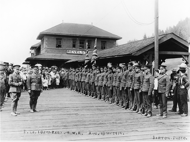
From the Sudetenland to the Alaska Highway
By Andrew Farris
Welcome to Peace Country & the Second World War: From the Sudetenland to the Alaska Highway. On this driving tour, you’ll travel from Dawson Creek to the Kiskatinaw Trestle, exploring how global events of the Second World War shaped this quiet corner of northern British Columbia. Along the way, you’ll visit historic sites and hear stories of refugees, airfields, and the builders of one of the most extraordinary highways in history.


The City of Dawson Creek acknowledges that we are privileged to live and work on Treaty 8 territory and the traditional home of the Cree, Dane-Zaa, Saulteau, Sikanni and Slavey First Nations. We value the Métis Peoples that live and gather here.

1. The Visitor Centre

This tour starts at the Dawson Creek Visitor Centre in Northern Alberta Railway (NAR) Park. Flip over to the next stop for directions to our first destination at today's Northern Lights College. Turn on the audio and listen as you drive, and we encourage you to get out and check out each of these stops on our journey.
2. To Northern Lights College
1939-1958
On the first leg of our journey we're going to visit Dawson Creek's historic airfield and Royal Canadian Air Force station, which is now the site of Northern Lights College.
Starting from the parking lot of Northern Alberta Railway Park, let's turn left back onto the Alaska Highway, or Alaska Ave. Then you'll turn right at the main roundabout and drive south down 8th Street. Continue to 112th Ave where you'll turn right. Continue over the bridge and it'll be your second right, where the Traveller's Inn is.
* * *
Though established the same year Canada entered the Second World War, it initially had limited utility in the fight against Germany. This changed in June 1941, when Hitler invaded the Soviet Union.
Through the lend-lease program, the United States, Britain, and Canada began supplying desperately needed military equipment to the Soviets. It was sent via dangerous Arctic convoys, or on a lengthy land and sea route through Persia and Central Asia. There was also a third, lesser known route, of which this airfield became a part.
While the Japanese prevented the Americans from shipping lend-lease supplies across the Pacific by sea, it was possible for aircraft to be flown from Alaska to Soviet territory in Siberia.
As such the Allies set up the Northwest Staging Route, a chain of airfields, radar stations, and emergency airstrips from Edmonton to Siberia. Aircraft could roll straight off North American production lines and be flown in relays over these remote and inhospitable regions and transferred to Soviet aircrews. The airfield became Royal Canadian Air Force Station Dawson Creek and served as an emergency landing strip for aircraft flying along the Northwest Staging Route.
Later on we will see how these airfields became a vital factor in the decision to route the Alaska Highway on this northerly route through Dawson Creek.
After the war the airfield fell into disrepair as for a time there was not yet any commercial air travel to pick up where the military had left off. Then in 1958 the field was closed and a new modern airport opened to the east of town (about 7 km away).
Some years later, in 1975, Northern Lights College opened on the spot of the original airstrip. It was to be the main community college serving British Columbia's north, with satellite campuses at Fort Nelson and Cassiar added soon after.
3. To Walter Wright Pioneer Village
1938
We have to make one more quick stop before we start our journey down the Alaska Highway. Next we will be heading to the Walter Wright Pioneer Village. To get there we're going to loop back towards downtown where we started. Continue going straight west on 112 Ave until the street ends and you reach the intersection with 13th Street.
Turn right at 13th Street and head north 400 metres until you reach the fork in the road.
At the fork turn right onto 10th Street.
Continue 1 kilometre on 10th Street until you reach the end and you're at the intersection with the Alaska Highway, opposite the Dawson Creek Visitor Centre .
Turn left onto the Alaska Highway and continue down it 2.2 kilometres. The road will have a slight turn to the right at around the 2 kilometre mark, where the Alaska Highway intersects the John Hart Highway.
Continue on the Alaska Highway a short distance past the highway interchange, and on your left you will see signs for the Walter Wright Pioneer Village. Turn left off the highway and continue down the short road to reach the village.
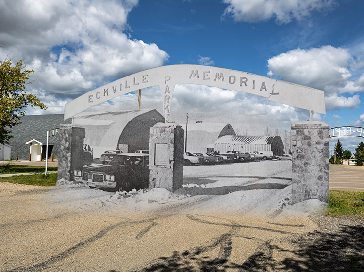
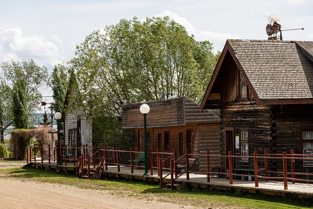
The Walter Wright Pioneer Village is a remarkable collection of original historic buildings and painstakingly rebuilt replicas that were once located across the region. To complete the picture, donations of artifacts, vintage vehicles, and farm machinery tell the story of the area's first settlers. The Park is a wonderful journey back in time and absolutely worth a visit.
It is open seasonally to visitors from May long weekend to September long weekend.
It should come as no surprise that the Walter Wright Pioneer Village was the brainchild of Walter Wright, a long-time Dawson Creek resident and businessman, who had a deep passion for preserving the Peace Country's rich pioneer history. Wright had long dreamed of creating a representation of a Peace Country town during the pioneer days, that is between 1912 and 1945. In his role as president of the South Peace Historical Society during the 1960s, he worked tirelessly to bring his dream to fruition. In 1970, working with local and provincial government, service clubs, and a host of volunteers, the Pioneer Village opened to the public.
* * *
The Hall is named for the Sudeten Germans, a people who lived in the Sudetenland, a mountainous region in the north and west of Czechia, or the Czech Republic.
The Sudeten Germans originated in the 12th century, when the Czech Kings of Bohemia invited Germans to settle in this underpopulated part of their lands. These German settlers came to see themselves as Bohemians and in the centuries that followed they lived harmoniously alongside their Czech neighbours, prospering as craftsmen and traders.
The region contained valuable supplies of coal and iron ore, and in the 19th Century the Sudetenland became heavily industrialized. By the First World War it had become a major centre of armaments production in the multi-ethnic Austro-Hungarian Empire.
In 1918, with Allied victory in the First World War, the Austro-Hungarian Empire was dissolved. Where it had been, 5 new countries appeared on the map of Europe. One was Czechoslovakia.
Many Sudeten Germans wished to have their own independent state or become part of the ethnic German nations of Austria or Germany. The new Czech government however was loath to lose this immensely valuable region, and the Czech army occupied the Sudetenland before the Sudetens could plead their case at the Paris Peace Conference. When the Sudeten Germans took to the streets in protest, Czech troops opened fire on the crowds killing 54.
Through the 1920s and 30s most of the 3 million Sudeten Germans more or less reconciled themselves to Czech rule. However, the Czechoslovakian state's economic, cultural, and language policies heavily favoured the majority Czech and Slovak regions. This created grounds for discontent amongst the Sudeten Germans. Adolf Hitler would exploit this discontent.
When Hitler rose to power in 1933, he sought to reunite all ethnic Germans into a single German nation. After he annexed Austria, an event called the Anschluss, he set his sights on the Sudetenland. Aggressive Nazi propaganda into the region found a receptive audience in some quarters, and some right wing Sudeten political parties started demanding unification with Germany.
There were many Sudeten Germans, however, who saw Hitler's true nature. Foremost amongst them were the Social Democrats, led by men like Wenzel Jaksch, who tried to fight growing Nazi pressure on Czechoslovakia. In persuading their own people, they largely succeeded, and some historians argue that the majority of Sudeten Germans preferred to stay within Czechoslovakia. In the end however, they were never asked their opinion.
Hitler threatened to invade Czechoslovakia if the Sudetenland was not given to him. The Sudeten crisis, as it became known, came to a head in September 1938. British Prime Minister Neville Chamberlain, hoping to avoid a repeat of the horrors of the First World War, flew to Munich to negotiate with the Nazi dictator. Without consulting the Czechs, he agreed to cede Sudetenland to Germany in exchange for Hitler's solemn promise not to demand any more territories. The Munich Agreement that Chamberlain said had brought "peace in our time" has become the byword for the appeasement of tyrants ever since.
The agreement was a catastrophe for the Sudeten Social Democrats. Their horror was amplified by the recent news that the Nazis were preparing their concentration camps to receive thousands of Sudeten Germans. As the German army began marching in, tens of thousands fled to the remaining parts of Czechoslovakia. The Czech government, betrayed by its Allies, and deprived of its armaments factories and border fortresses, was terrified of further provoking Hitler and sent whole trainloads of refugees back into the Sudetenland. The Nazis immediately rounded up 20,000 political opponents and sent them to concentration camps like Dachau. Few would ever emerge.
Some 30,000 did manage to flee into the rump state of Czechoslovakia or to Britain. Britain's Foreign Office asked Canada to accept some of these refugees, even offering to pay $1,000 per refugee family. Shamefully, the Canadian government balked at this request. After months of wrangling, and demanding $1,500 per family, it was only with great reluctance the Canadian government agreed to take in 1,200 families. Tragically, while these negotiations were going on Hitler had gone ahead and marched his army into the rest of Czechoslovakia. Many of those refugees Canada had belatedly agreed to take in instead disappeared into the concentration camps.
In the end 303 refugee families and 72 single men who had previously managed to get to Britain were settled in Canada. 152 families and 37 single men, half the total, were settled in the backwoods area of Tomslake and Tupper, about 25 km south of Dawson Creek. Though they had been city dwellers Czechoslovakia they were banned from settling in Canadian cities. Instead they were required to become farmers. Imagine their shock at being dropped in this harsh climate, in this remote corner of British Columbia, with no house or source of income, and being expected to learn to farm. Yet they adapted and established a prosperous, tight-knit community.
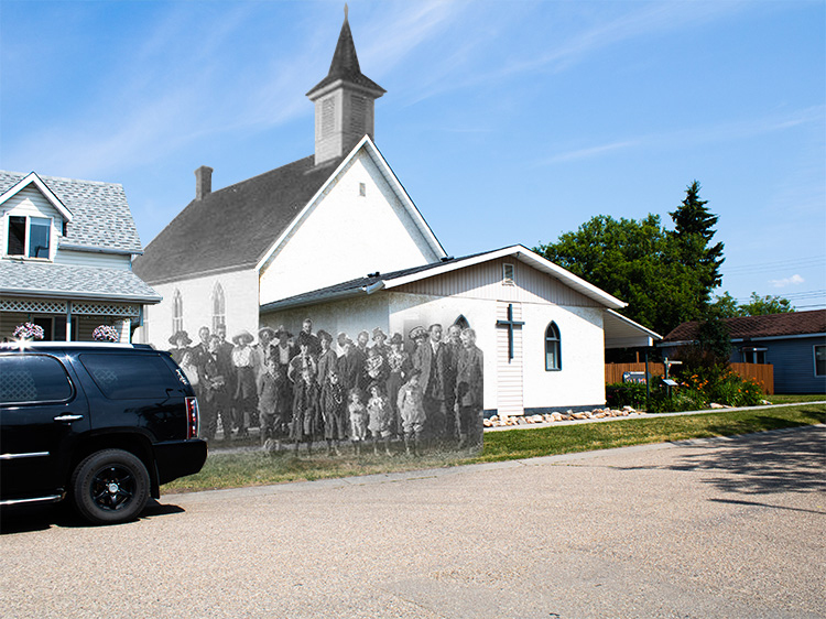
The first Sudeten Hall, a log structure, was built by these refugees in May 1940 to serve as their community centre. A fire in 1953 destroyed it, but two new ones went up in its place. In 1990 the Tomslake Canadian German Association donated one of them to the City of Dawson Creek, and it was incorporated into the Pioneer Village where you can see it today and learn the story of how these early German opponents of Hitler came to become an integral part of the story of the Peace Country.
4. To Kiskatinaw Bridge
1942-43
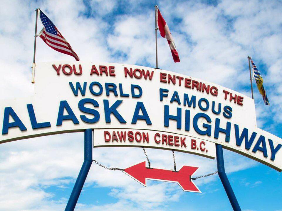
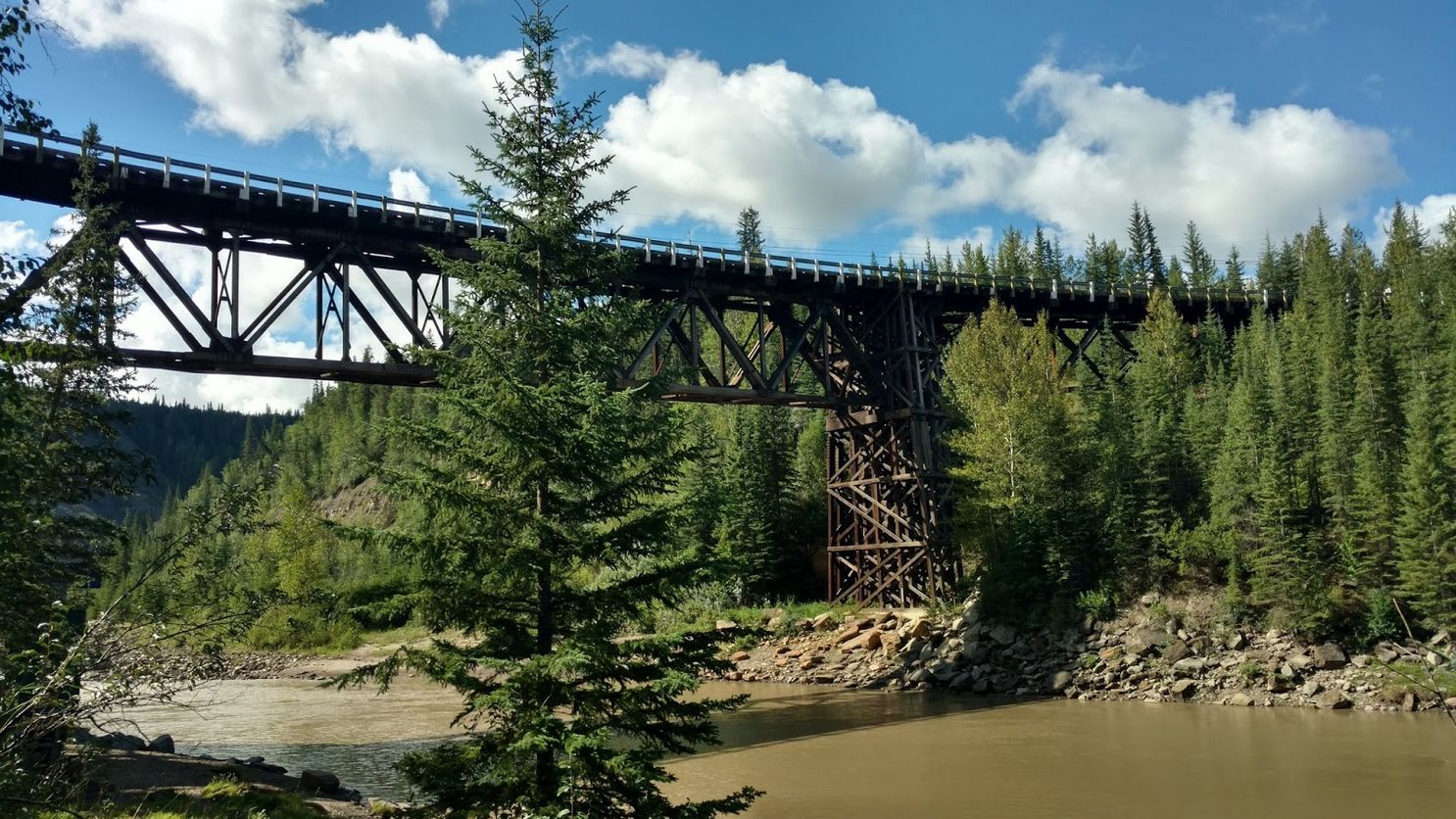
Now that we've visited the Pioneer Village, it's time to set out from Dawson Creek and head north, along the legendary Alaska Highway. The Alaska Highway is over 2,300 kilometres long, stretching all the way through the Yukon to Delta Junction, deep in Alaska's interior. For our purposes here we are just going to cover the first leg of the journey, to the Kiskatinaw Trestle in Kiskatinaw Provincial Park. It's about a 35 kilometre drive and should take just about 25 minutes.
To get there you simply continue northwest on the highway out to Dawson Creek. The trestle in Kiskatinaw Provincial Park is located along the Old Alaska Highway, which you'll need to turn on to about 25 kilometres north of Dawson Creek.
When you see the signs on your right for the Old Alaska Highway and Kiskatinaw Provincial Park, turn right onto the old highway, and then quickly turn left to head north down the Old Alaska Highway. The road will become gravel and after a couple of kilometres will take a winding course down into the river valley until you reach the trestle bridge.
At the time of writing the bridge is closed to traffic, and the signs will say that. Do not worry, you can still drive up to the bridge and walk across it, while exploring all the park has to offer.
* * *
"The Alaska Highway was not built for tourists. It was a road built in 1942 out of anger after Pearl Harbour, out of fear that the Japanese would invade Alaska. It was a military supply line and speed, not scenery, was the prime consideration. It went wherever a bulldozer could go, rammed through a remote wilderness of mountains, muskeg and mud.."
The writer and northern explorer Philip Godsell, who witnessed the highway's construction and wrote a book about it in 1944, declared: "the story of the Alaska Highway is one of vision and conception magnificent in scope, and of enterprise equally grand in accomplishment. It is a story of brains, brawn and engineering skill pitted against the unrelenting forces of nature."
1. The Threat
At the end of 1941, Canada had already been at war with Nazi Germany for over two years. Canada was mobilizing for war, and a Canadian Expeditionary Force was in England training for the assault on Hitler's Fortress Europe.
The United States had remained neutral, though they recognized that the war might soon come to their doorstep, and in 1940 the American and Canadian general staffs formed a Permanent Joint Board of Defense to coordinate the defense of North America. At the board's first meetings it is clear their eyes remained firmly fixed on Europe and the German Navy's U-boat threat in the Atlantic.
In the northwest, the Territory of Alaska (it wouldn't become a state until 1959) was isolated and exposed. There was no land connection to the territory, and it was close to the ruthlessly expansionist Empire of Japan, which was then engaged in an apocalyptic invasion of China which would ultimately see the deaths of over 15 million Chinese.
Nevertheless all the Canadian and American generals on the Defense Board agreed that a land connection to Alaska was unnecessary, and its military value would be "negligible."
The Japanese for their part were paying close attention, and they were greatly disturbed by newspaper reports that a highway was even being discussed. The Imperial government issued a statement calling the construction of a highway to Alaska a provocation. "American measures in this direction will be regarded as a continuation of the horseshoe-shaped encirclement of Japan by the Washington Government."
In hindsight it seems obvious why the Japanese would be so interested in a highway to Alaska. Just a year later, on December 7, 1941, Japanese carrier aircraft launched the devastating surprise attack on Pearl Harbor, starting the Second World War in the Pacific.
That a Japanese fleet could launch hundreds of carrier aircraft and strike at Pearl Harbor, some 6,400 kilometres from Japan, was shocking enough. But they also launched simultaneous attacks by land, sea, and air on British and American bases throughout the Pacific: in the Philippines, on Guam, Wake Island, Malaya, and Singapore.
2,000 Canadian troops were on garrison duty in the British colony of Hong Kong. Within hours of Pearl Harbour they came under relentless Japanese assault. Heavily outnumbered, surrounded, and with no hope of relief, they were forced to surrender after a 17-day siege. More than 550 of these men would never return home, half killed in the battle, and the other half dying in the brutal captivity that followed. Hong Kong would be the only battle seeing large Canadian participation in the Pacific War.
The whirlwind Japanese offensive in December 1941 included attacks separated by over 9,000 kilometres, spanning nearly a quarter of the earth's surface. And almost everywhere they met with stunning success. It was the most daring and breathtakingly ambitious series of combined arms offensives in military history.
It seemed the Japanese could strike anywhere at any moment, with overwhelming land, sea, and air power. Alaska, which is much closer to Tokyo than Hawaii, looked very vulnerable indeed. For its defense the Americans could call upon 23 obsolete fighter aircraft and 5 leaky destroyers. Without a land connection it had to be supplied by sea, and it looked entirely possible the Japanese could sever this lifeline. In the first six months of 1942 there were 134 reports of Japanese submarines and aircraft up and down the West Coast. A Japanese submarine surfaced off Estevan Point on Vancouver Island and fired its deck gun at the lighthouse contributing to the sense of panic.
2. The Plan
In this atmosphere of fear and uncertainty it becomes easy to understand why the Alaska Highway rocketed to the top of the priority list. The Americans now applied to this task frantic energy and colossal resources. Before the war highway commissioners had estimated building this highway would take at least five or six years. The US Army needed it done in less than one. The job was given to Colonel (soon to be Brigadier-General) William Hoge, a gruff 48-year-old First World War veteran, who said "We'll go as fast as it is possible to do the job."
But where to build it? Since the 1920s highway advocates had spent years painstakingly surveying two potential routes through British Columbia, both starting from Prince George. The first, Route A, kept close to the coast and reached Whitehorse via Telegraph Creek. Route B went further east and north through the Rocky Mountain Trench and then swung around to Dawson City in the Yukon. Both of these routes were strongly advocated for by powerful Seattle-based business interests that dreamed of dominating the prospective business and tourism opportunities in Alaska.
The US Army Corps of Engineers looked at both these routes and found they were both mountainous, with challenging topography, and close enough to the coast to be vulnerable to attack by Japanese bombers or paratroopers.
So the Army Engineers went ahead and came up with their own route, the Prairie Route. It started at Dawson Creek far to the east and north of the other proposals. It then proceeded north through the Peace Country, to Fort Nelson via Fort St. John. There it turned west to cross the Rockies, passing through Whitehorse before terminating at Fairbanks in the interior of Alaska. It was safe from attack and had the added advantage of following the chain of air strips recent established to send aid to Russia--the Northwest Staging Route we saw earlier in the tour.
Next the US and Canada had to agree. There had been intergovernmental discussions of a highway since the 1920s. But the parsimonious Canadians, through whose territory most of the highway would go, were reluctant to foot most of the bill for a project where the benefits would accrue mostly to the Americans, save for a couple thousand Canadians living in the Yukon and northern British Columbia.
Now in 1942 the Americans were in no mood to quibble about dollars and cents. The US Army offered to build the road, pay for it, and then turn it over to Canada after the war. For its part Canada would allow access to the land, the use of gravel and timber for construction. It was, to put it mildly, a pretty good deal for Canada. As one rather smug sounding Canadian observer enthused, "You provide the toil, we'll provide the soil."
In late February 1942 Colonel Hoge and an engineer from the US Public Roads Administration went to scout the new route. Dawson Creek was the end of steel for the Northern Alberta Railway, so the NAR would have an important part to play in the drama about to unfold. Hoge and the engineer went to the NAR's office in Edmonton to tell them what was about to happen.
James McArthur's job managing the Northern Alberta Railway was not an overly stressful one. The maps in his office showed just two train tracks radiating out from Edmonton punctuated by markers showing the locations of the 16 locomotives and couple hundred wagons that the NAR owned. One of the tracks went west to the new town of Dawson Creek, which had been officially founded just a decade before. The other went north to a remote settlement on the Athabasca River few people had ever heard of save for some rumours about oil. It was called Fort McMurray. And it was the middle of a freezing winter, so there wasn't much demand for rolling stock.
When two high ranking US military men strode into McArthur's office and began telling him about their plans for his railway, he thought they were playing a prank. "At first I could hardly credit my ears... I checked the credentials, consulted the proper sources, and was convinced. I realized what all this was to mean for us.”
McArthur took the Americans to Fort St. John, where they hopped in a spotter plane to scout the route. The Americans liked what they saw. Back in Edmonton they placed a phone call to Washington. It was March 1. By the next morning trains filled with US Army Engineers were already rolling, bound for Dawson Creek.
The starting gun had fired on one of the most challenging and ambitious engineering projects of the 20th century. As one historian put it: "Seldom has a project of this magnitude been undertaken with such haste and so little planning."2
When the decision was announced to the public it created an uproar. Some thought that building this highway wasn't even possible, like the Member of Parliament for the Yukon, who argued the deep muskeg swamps would turn the highway into an impassable muddy morass for much of the year.
The titans of Seattle business were stunned: With the Prairie Route they faced losing control of Alaska's post-war development to Edmonton of all places.
The Alaska International Highway Commission couldn't believe they had not been consulted. How could the army think they knew better than them? They released a sarcastic and condescending statement.
"We are delighted to hear through the Press that the road to Alaska is to become a reality and that the army has belatedly accepted the view which your commission has been urging upon it for years.
"However we know that the army is making a serious blunder in the selection of the route, if it is to be built as reported, and would strongly urge the army to confer with this commission which has studied this thoroughly for four years. The route reported cannot possibly be built within the time limit supposedly announced for it."
When the army didn't bother to respond, they frantically lobbied congress to force the highway to follow the A or B Routes. But it was too late. The war had given the highway a momentum of its own.
3. The Engineers
At first they called it the Alcan, a portmanteau of Alaska and Canada, which was abandoned in 1943 because it sounded too much like oilcan. Seven regiments of US Army Engineers were assigned to the task, numbering almost 11,000 men. They were to work from three sections at once, with the sections working towards each other. In the north one force would be based at Delta Junction, Alaska. Another force worked from the middle section in Whitehorse, in the Yukon, provisioned by supplies brought over the White Pass. The southern effort, and the largest, was based in Dawson Creek.
This section was put under the command of the hard-driving Major General James A "Patsy" O'Connor. A short, spry man in his 50s, he was "Frequently to be seen by his men bouncing through the muskeg in a jeep, his face and uniform blackened with grime, right behind the ‘cats’ as they forged through the primeval wilderness."3
There already existed a "passable" stretch of road from Dawson Creek north to Fort St. John, the stretch of road you are driving along now. From Fort St. John to Fort Nelson, which was to become a major advance base, the road was little more than a trail. After that there was only wilderness.
On March 9th the 35th Engineers were the first to arrive in Dawson Creek. It was a bitterly cold day. Godsell wrote that for some of the men, who came from places like Louisiana, Texas, or Florida, it was the first time in their lives they had ever seen snow. "It might as well have been the end of the world."
"One oft-repeated tale concerns a staff sergeant who, arriving in Dawson Creek during a blizzard, asked his superior officer, ‘Major, where do I sleep?’ The grinning major replied, as he put down his own bag, ‘Take any snowdrift you like. This one is mine!’"1
There was no time to waste. Racing to beat the spring thaw that would make the trail impassable, an advance party force marched the 450 km to Fort Nelson.
By the ice breakup on April 10th, a regiment of 1,200 men were set up in a sprawling camp of canvas Nissen huts at Fort Nelson.
Thousands more were to follow, bringing with them thousands of pieces of equipment, including 174 steam shovels, 374 graders, 900 tractors, and 5,000 trucks, not to mention a bewildering array of bulldozers, generators, snow plows, and cranes.1 5
The engineers could not have been under any illusions about the conditions they would face. The recruitment notices did not sugarcoat things. One read:
"THIS IS NO PICNIC. Working and living conditions on this job are as difficult as those encountered on any job ever done in the United States or Foreign Territory. Men will be required to work and live under the most extreme conditions imaginable. Temperatures will range from 90 degrees above zero to 70 degrees below zero [that is 32 Celsius to -60 Celsius]. Men will have to fight swamps, rivers, ice and cold. Mosquitos, flies and gnats will not only be annoying but will cause bodily harm. If you are not prepared to work under these and similar conditions DO NOT APPLY."
Construction crews worked in shifts around the clock. Tractors would clear a 15 to 30 metre wide path through the forest. Bulldozers and graders would follow, leveling the ground. After that culverts and ditches would be dug, before a final crew graded the surface. At least that's how it was supposed to work.
The reality was often much more torturous. The Army Engineers had no idea how to handle permafrost, which would quickly thaw and turn into a muddy morass. They resorted to laying down tree trunks to create corduroy roads, though these required frequent replacement. Most of the highway you're driving on today is still laid on top of these corduroy foundations.
The freezing and thawing of the permafrost caused the ground level to undulate over time. In response, piles had to be driven down 70 feet and encased in pipe that could rise and fall with the surrounding ground.
Depending on the season, extremes of mud, cold, and dust took an enormous toll on the 1940s-era equipment, and before long the highway was strewn with broken and abandoned trucks and tractors. Supplies of food sometimes couldn't get through and the crews had to go hungry. Drivers at the wheel for 20 hours at a stretch would drift off and tumble over steep embankments. One grade was so steep it accounted for at least one fatality and earned the nickname Suicide Hill. Some novice drivers, ignorant of the severity of the cold, froze to death as they napped on the side of the road. Others drowned while attempting to bridge the freezing rivers.
The 93rd, 95th, and 97th Engineering Regiments were segregated black units. These men, often from the Deep South, had no concept of Arctic conditions. They were also subjected to a range of racist restrictions. Astonishingly, they were not allowed to use heavy equipment. They actually had to build their sections of the highway with pickaxes and shovels. They were banned from entering Dawson Creek itself and assigned to the most remote and difficult stretches of highway.
Nevertheless they worked "day and night, without recreation or relief," wrote the historian of the National Park Service. And, "despite their lack of power tools and machinery", when it was all said and done the "black soldiers completed a longer stretch of the road than their white counterparts."4
"In light of their impressive performance," he continued, "many of the black soldiers who worked on the Alcan were subsequently decorated and sometimes deployed in combat. Indeed, the U.S. Army eventually became the first government agency to integrate in 1948, a move that is largely credited in part to the laudable work of the soldiers who built the Alcan."
Despite all the difficulties, Major General O'Connor made every effort to keep morale high. He even had the regimental bands play for the exhausted construction crews as they worked, the martial music echoing eerily through the vast boreal forests.
To those who lived in these northern lands, First Nations peoples like the Beaver and the Dene-zaa, as well as a handful of white traders and trappers, encountering the highway builders was like stepping into the future. "We were taking goods into the north by horse and dog sleighs the way our fathers and grandfathers had done," recalled one trader. "When we met . . . a great fleet of trucks as far as the eye could see . . . . [T]ime went ahead more in a few minutes than it had in a whole lifetime. Like the snap of your fingers, we changed from the old to the new."1
4. The Canadians
In June, several months into the project, construction reached a new pitch of urgency when everyone's worst fears were realized: the Japanese actually did invade part of Alaska: the Aleutian islands of Attu and Kiska.
The US Public Roads Administration redoubled its efforts and hired 5,000 civilian contractors to augment the engineers. This time three quarters of them were Canadian.
Ontario's Phyllis Lee Brebner was one of about 100 young women from across North America brought on as clerks for the large civilian contracting companies that set up a base in Fort St. John. Perhaps unsurprisingly, these women became the object of intense interest, both amongst the thousands of men working alongside them, as well as in the press. One American newspaper called them the "Alaska Amazons," a nickname that stuck. After the war Brebner became a journalist, writing several books about her experiences on the Alaska Highway.
Brebner remembers how the civilian contractors were pushed just as hard as the engineers, and the rigorous conditions meant turnover ran as high as 100%. To their great dismay, the Canadians quickly discovered that their American counterparts were getting paid nearly twice as much. The average Canadian contractor's wage was $0.86 an hour, while their American equivalent made $1.57. Over a gruelling 77 hour work week, a Canadian trucker made $69. An American trucker on the same schedule made $136.
The Americans got better food too. Brebner recalls getting sick of the monotonous rations of "powdered eggs, sauerkraut, dehydrated potatoes, and banana flake pie," served in Canadian cafeterias. They looked over enviously at the American cafeterias where wartime luxuries of chicken, olives, and green vegetables were frequently on the menu.
The Canadian Government, embarrassed by this disparity, responded by segregating the Canadian workers into their own camps and asked the Americans not to make their Canadian counterparts aware of their relative poverty. "At first US camps, under orders, refused to feed Canadian workers who might find themselves stranded at American camps at meal times. Canadian camps, in retaliation, soon refused to serve Americans." This worked only to further inflame the situation, so "These difficulties were soon ironed out."
"Over such grievances the Canadian worker soon became vocal, asserting loudly that if the CCF [that is, the forerunners of the NDP] were in power such inequalities wouldn’t occur." Some responded by thinking Canada should simply join the US, which would evidently have a salutary effect on wages. Others, awestruck by the overwhelming American military might on display, had the uneasy feeling they might refuse to leave after the war was over.
The locals in Dawson Creek had little time to consider the implications of the whirlwind transformation of their town. A headline in Dawson Creek's Peace River Block News read "United States Troops Invade Dawson Creek to Build Alaska Road."
Godsell wrote:
"Dawson Creek at the end-of-steel daily added new spurs to accommodate the lines of flatcars loaded with bulldozers, trucks, cranes, giant scrapers and bulging boxcars. As the station increased four-fold in size a boom frontier town of cafes, poolrooms, frame hotels, warehouses and barber shops arose to the eternal tattoo of carpenter’s hammers. Within a miraculously short time the hamlet of Dawson Creek with its three hundred population became a rip-snorting frontier town of ten thousand with a floating population ever passing to and fro."3
Over the summer the pace of construction never let up. Finally on September 25, at Contact Creek, "a bulldozer driven by a member of the 340th Regiment from Whitehorse almost collided with another driven by one of the 35th Regiment working north-east from a point 355 miles west of Fort Nelson." The teams working in Yukon and Alaska met up soon after.
5. The Achievement
On November 21, 1942, the 1,523 mile Alaska Highway was completed. The feat which so many had called impossible, had taken just 9 months and 6 days. At a ceremony on Soldiers Summit in -30 Celsius, Canadian and American government representatives gave congratulatory speeches and a mountain-top banquet was held.
Lieutenant Neuberger wrote in a letter home about the emotional impact the occasion had upon him. "The crimson tunics of the Mounties mingled with the sombre khaki of their American allies." As both national anthems were played, "I looked around me at the stern faces of the American soldiers and the grim countenances of the Mounties, I felt that in such a scene as this lay the future of the United Nations–that in the ability of us all, Canadians, Americans, and Alaskans, white and black, civilian and soldier, to fuse together our efforts in such a project as the Alaska Highway rests the hope of the free peoples throughout the earth."3
There remained much work to do to improve the many steep grades, haphazard road surfaces, and narrow hairpin mountain turns. And of course there were the hundreds of creeks and rivers, which had been hastily bridged with pontoons or temporary wooden bridges that washed out with exasperating frequency. These would all have to be upgraded to permanent structures. This was work that would continue throughout 1943, however by then the urgency of the task had receded.
In the months that followed overwhelming Allied (primarily American) firepower pushed the Japanese back across the Pacific theatre. It quickly became apparent that June 1942 had been the high water mark of Japan's imperial project. Attu and Kiska were retaken and Alaska was made safe.
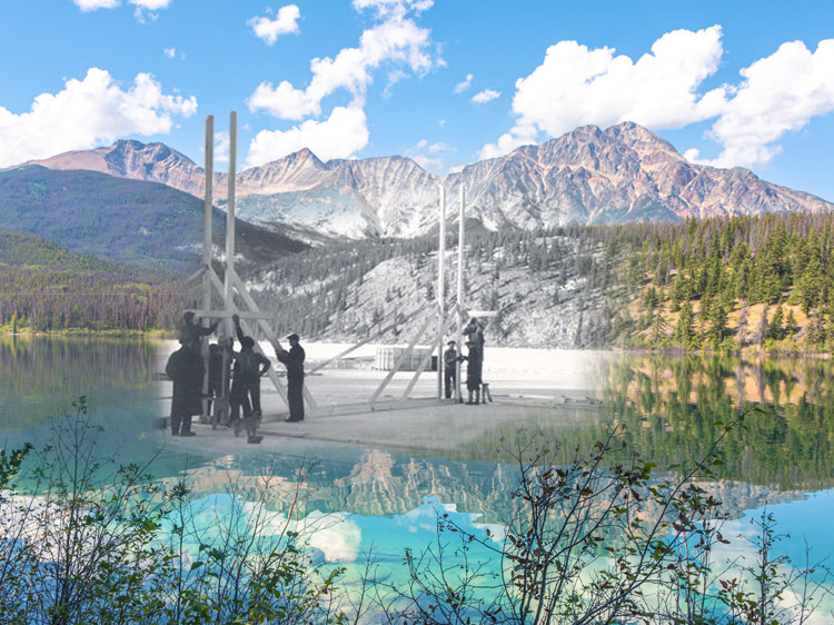
The Kiskatinaw Trestle that stands today was one of those built in the second phase of construction in 1943. It was built by Canadian civilian contractors. The Kiskatinaw River had first been bridged with pontoons at the start of 1942, and later with a small temporary bridge at the bottom of the gorge. But a more permanent solution was necessary. The 162-metre curved trestle bridge that spans the gorge was the first of its kind in Canada. You can still walk across it today at the very end of this tour. It took 9 months to build and remained in service until 1978, when the Alaska Highway was rerouted 10 kilometres to the west, as the bridge was not thought able to support the increasingly heavy loads hauled by modern trucks. Nevertheless it is the only original wooden bridge still in (some) use from those years.
In all this mammoth undertaking cost $147 million USD, that is $3.2 billion Canadian today.
All along the highway's length, the Americans vanished just as suddenly as they had appeared. A friend of Phyllis Brebner visited the Highway in August 1944 and wrote to her about the experience: "Dawson Creek is like a morgue, hardly a person on the street… Very few US soldiers around… The road is not very good – very little maintenance. Fort St. John is also somewhat morgue-like. It is still infested with US soldiers in various stages of dress and undress and sobriety, but they will, I believe, soon leave us."
After the war the highway was handed over to the Canadian government as agreed, and in 1948 it was opened to the public. For many years it was legendary as one of the most challenging drives on the continent. But it has since been fully paved and straightened out, so that it is now about 150 miles shorter than it was in 1942. Today this beautiful scenic drive that starts at Mile 0 in Dawson Creek still draws around 350,000 tourists every year.
We hope you've enjoyed this audio tour.
Bibliography
Alaska Highway Community Society. "Highway Builders." https://ouralaskahighway.com/?v_category=highway-builders
Brebner, Phyllis Lee. Alaska Highway: A Personal Account of the Building of the Alaska Highway. Boston: Boston Mills Press, 1985.
Canadian Council for Refugees. "A hundred years of immigration to Canada 1900 - 1999."
Ingram, Rob. "The Alaska Highway: A Thematic Overview." Yukon Government. February 1991. https://emrlibrary.gov.yk.ca/Tourism/alaska-highway-a-thematic-overview-1991.pdf
Godsell, Phillip H. Alaska Highway. London: Sampson Low, Marston and Company, 1944.
Pierce, J. Kingston. "The Biggest and hardest job since the Panama Canal," American History, 2001-02, Vol. 35(6), p.52.
National Park Service. "Black History in the Last Frontier: Alaska Highway Engineers." https://www.nps.gov/articles/000/black-history-in-the-last-frontier-alaska-highway-engineers.htm
Western Canada Sudeten German Alliance. "The Sudeten Story." https://www.mile0park.ca/sudeten-display